Gotland Deep
These simulations are made for the location of station 271** Central Eastern
Gotland Sea of the Baltic Sea** at 20 deg E and 57.3 deg N with a water depth
of 250 m. Initial conditions for temperature and salinity are derived from
measurements. Meteorological forcing was available from the ERA15 reanalysis
data set. For the penetration of solar radiation into the water column, fairly
turbid water (Jerlov type IB) is assumed. Salinity concentrations are nudged to
observations with a time scale of 50 days.
[caption id=“attachment_520” align=“aligncenter” width=“640”]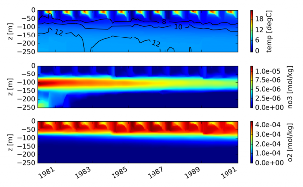 Simulated temperature, salinity contours and examplary ERGOM state variables
in the Central Baltic Sea. This plot was created with
gotland.py.
[/caption]
The simulation is carried out for the years 1980-1990. For the discretisation,
the water column has been divided into 100 vertical layers, with a strong
zooming towards the surface, resulting in a mean near-surface resolution of
less than 0.5 m. The time step for these simulations is set to 10 minutes. For
details of the gotland scenario see
Burchard et al. (2006).
Simulated temperature, salinity contours and examplary ERGOM state variables
in the Central Baltic Sea. This plot was created with
gotland.py.
[/caption]
The simulation is carried out for the years 1980-1990. For the discretisation,
the water column has been divided into 100 vertical layers, with a strong
zooming towards the surface, resulting in a mean near-surface resolution of
less than 0.5 m. The time step for these simulations is set to 10 minutes. For
details of the gotland scenario see
Burchard et al. (2006).